Extreme UK flood levels are happening much more often than they used to, analysis shows
Original article by Louise Slater and Jamie Hannaford republished from the Conversation under Creative Commons Attribution-No Derivatives licence.
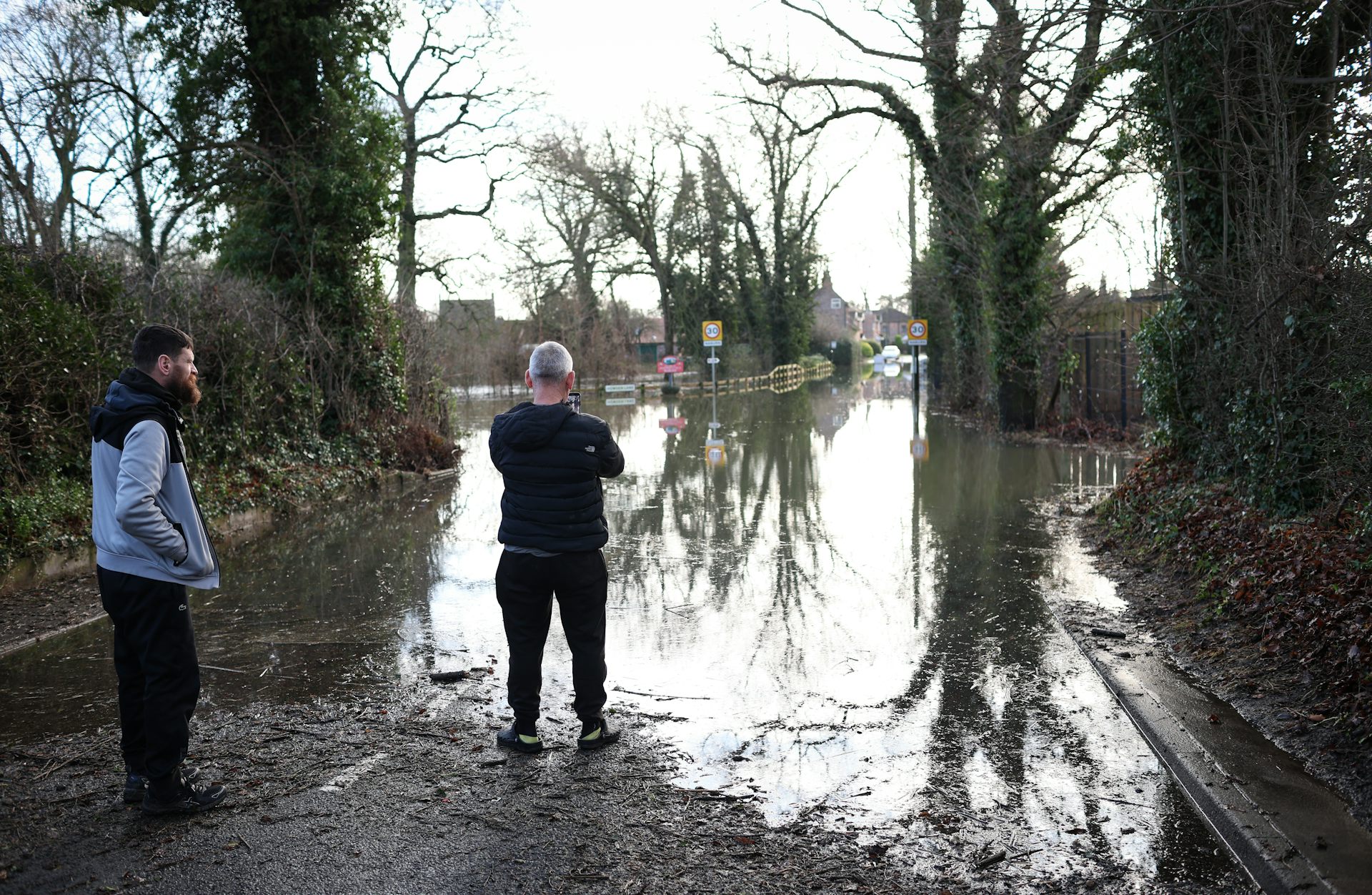
Heavy rain across southern Britain meant that most rivers in England swelled at the beginning of 2024, prompting widespread flooding.
The River Trent was among the most severely affected. Water levels at the Drakelow gauging station in the west Midlands reached 3.88 metres on January 4 – well above the previous record set less than four years earlier in February 2020.
Are floods growing larger and happening more often in the UK? There are two ways to answer this question. One is to consult computer models which project Earth’s climate in the future, and the other is to search the historical record.
Climate projections are important but highly uncertain as they indicate a wide range of potential futures for any given river. Projections also only tell part of the story as they do not reflect the patterns of water use, changes to groundwater levels or to the urban environment that can decide flooding on a particular river.
That’s why we give equal importance to historical data, although we cannot project past changes directly into the future. Historical archives of river monitoring data can help us understand how the largest floods are changing on the River Trent.
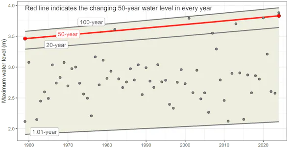
For instance, how is the 50-year water level (the highest point a river would be expected to reach in 50 years on average) changing? On the River Trent at Drakelow, the 50-year water level has risen from about 3.46 metres in 1959 to 3.83 metres in 2024. This means the largest floods are indeed getting bigger.
How the January 2024 floods compare
The flood water level on the Trent at the start of January 2024 was actually higher than what scientists would consider a once-in-50-year event in today’s warmer climate.
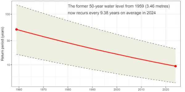
Another way to understand how much floods have changed is to consider how often they happen today compared with the past. If we look at the 50-year level from 1959 (about 3.46 metres), how often would such a flood occur in today’s climate?
On the Trent, a 3.46-metre flood level would now be expected to occur every 9.38 years, on average, in 2024. This makes sense, considering there have already been six events in which the river level exceeded 3.5 metres since the 1980s. The historical data shows that extreme water levels are being reached more frequently on the Trent.
Our analysis of the Trent aligns with results from a previous study which looked at rivers across the rest of the UK. In many places, 50-year floods are now happening less than every ten years, on average.
This is partly due to climate change and also partly due to natural variations in the climate which see rivers cycle through spells of more and less flooding. The UK went through a “flood-poor” period in the 1960s, 70s and 80s, and has been going through a “flood-rich” period since then.
Prepare for worse
It is worth noting that there are caveats to this type of analysis which tries to assess how extreme events are changing over time. Caution must be exercised when looking at long records of river levels given changes in river management practices and measurement techniques over time.
It should also be noted that these results use a different methodology to the industry standard for flood estimation.
But what matters is not the precise changes in the frequency of major floods (from 50 years down to nine or even two-and-a-half years, according to some statistical methods). It is understanding that the frequency of large floods is changing fast.
For many UK rivers with more extensive historical archives of river level measurements, floods appear to be occurring far more frequently than before. In a smaller number of places, they are occurring less frequently.
We need to better understand how flood risk will evolve in response to further human-induced warming. The UK’s efforts to predict and prepare for future floods are supported by the Environment Agency’s flood hydrology roadmap, which is mobilising a wide community of researchers and practitioners.
Overall, the UK must prepare to live with bigger floods and be able to predict flood-rich periods several years ahead. This starts with an understanding of how the severity and frequency of such events is changing.
To support this effort, we are preparing a range of tools to guide flood planners, including an interactive map allowing users to explore how flood return periods are changing across the UK. Being better prepared for extreme events in a warming climate starts with understanding what it will mean for your local area.
Original article by Louise Slater and Jamie Hannaford republished from the Conversation under Creative Commons Attribution-No Derivatives licence.